
Lessons from COVID-19 will study geographic representations of three megaregions in the U.S.: Great Lakes, Southern Florida, and Southern California. Megaregions, as defined by the Regional Plan Association, represent a cluster of cities that: include a Core Based Statistical Area as defined by the Office of Budget and Management; are expected to experience population and employment growth over the next 25 years; and share similar environmental systems and topography, infrastructure systems, economic linkages, settlement and land use patterns, and culture and history (Hagler, 2009).
Given the physical expansiveness of the Great Lakes mega-region, our project focuses on the Minneapolis-St. Paul MSA and their surrounding outstate areas consisting of 32 counties in Minnesota and Wisconsin that form a congruent but distinct cluster (Fig 1). The megaregions, Southern California and Southern Florida, coalesce around the urban cores of Los Angeles (LA) and Miami, respectively. The three study regions highlight regional differences in sociodemographic and COVID-19 prevalence, as well as agri-food systems.
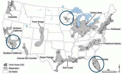
Figure by Jacob Napieralski